“Here is a cascade … filled with bounce and dance and joyous hurrah, yet earnest as a tempest …” - John Muir
If you are looking for a quick, easy hike, and enjoy the sound of cascading and tumbling water, and don’t want to spend a lot of time driving to a hike, there are three waterfalls on the West Shore that will fill the bill. All three are less than three miles in length, out-and-back, and with the recent warm weather, and advancing spring snow melt, all three are currently playing a deafening, thunderous tune.
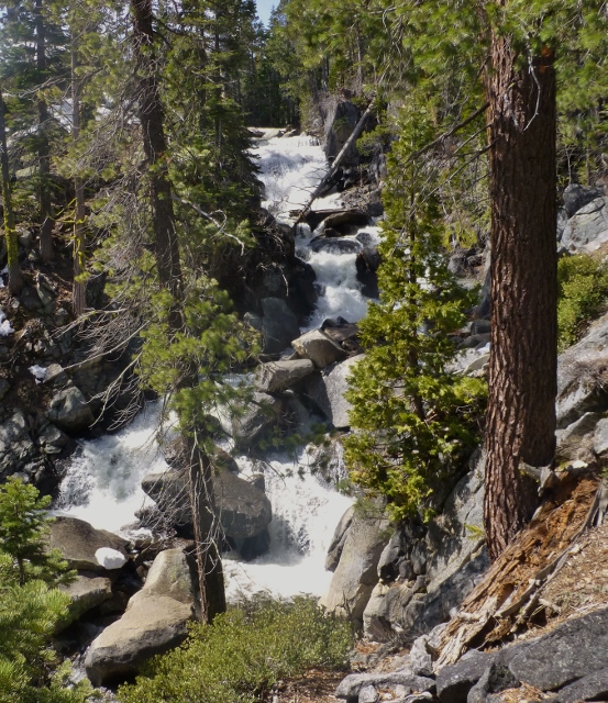
Cascade Falls
 Cascade Falls drops into Cascade Lake just south of Emerald Bay. After you drive past the land slide scar at the head of Emerald Bay on Hwy 89, turn right into Bay View Campground. Right now, the campground gate is closed, so park along the side of Hwy 89 and walk to the trailhead at the back of the campground. There are still scattered snow piles throughout the area. No wilderness permit is required to walk to Cascade Falls.
Although short in length, this trail requires some agility, as it travels along the upper south-facing slope of Cascade Lake along a portion of a lateral morraine left long ago by a retreating glacier. The boulders, small and large that were left by the glacier, produce some big, sandy steps as the trail slightly rises and drops on the way to the falls.
As the trail reaches the top of a wide granite ledge near the falls, take time to look around and observe this area. After wandering down to Cascade Creek over rocky slabs and slopes, remembering this spot will save you some time locating the trail on your return.
Eagle Falls
There are two waterfalls at the head of Emerald Bay where Eagle Creek flows down into Lake Tahoe. The upper falls are operated by the US Forest Service and the lower falls are in Emerald Bay State Park. There are parking lots at both trailheads that require the payment of a fee, or there is free parking in pull-outs along Hwy 89. Parking is limited and fills up fast most days, especially in the summer.
Our destination is the lower falls, 650′ feet below. The trail which is actually the old access road to the Vikingsholm, begins in the southeast corner of the Vikingsholm parking lot. Continue down the road, go past the home, and then over to the back of the Visitor Center where a 0.3 mile single track trail heads up to the base of the falls.
While working at the park, visitors would often ask how long the hike was. Our standard response was “one mile down, and two miles up,” so keep that in mind.
Meeks Creek Falls
 Not as well known or popular as the previous two hikes, the trail to Meeks Falls is mostly level and takes about 40 minutes one way. The trailhead parking lot is on the right-hand side of Hwy 89, just south of the Meeks Bay Resort entrance. Look for a small dirt lot, with a wooden building, trail info display, and green, locked gate. If you are just going to the falls, you do not need to fill out a Desolation Wilderness hiking permit.
The trail is a dirt Forest Service Road that passes through meadows for 1.2 miles. At a large pond, the trail to Genevieve and Crag Lakes takes off to the right while we continue straight on an un-maintained road over slightly undulating forest floor. Along the way, you may see remnants of an old girl scout camp.
Near the end of the road, you will hear the falls off to the right. Carefully work your way over a few logs, and scramble around and over some small boulders, and in about 50 yards you will reach the creek and the base of the falls.
Recently, the road to the falls had some large puddles from snow melt that can be easily by-passed, and near the falls where the area is heavily forested, there where still some piles of snow that are softening up and easy to post-hole down into, so take care if the snow is still there when you hike.
So there you have it, three close, easy, hiking adventures to view some beautiful waterfalls.
Tom